MENU
Itinerary: Mountain Biking Around Gorham, NH
Written by: Abby Evankow (Gorham resident)
 One of the appeals of this loop is that you can get on at several different points, from your motel in downtown Gorham, from your campsite at Dolly Copp Campground or Moose Brook State Park, or from the Rail Trail parking lot on Rte 2, just west of Gorham.
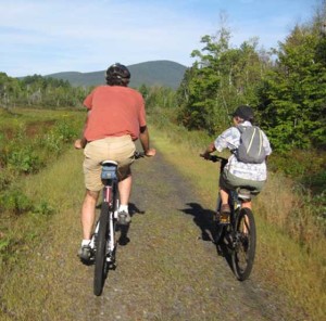
We got a late start on our mid-September ride because of a flat tire. Fortunately, Crooker Cycle Sports, (240 Glen Ave, Berlin, NH 603-752-3632) graciously replaced the defective tube so we weren’t held up for long. We parked at the Rail Trail Parking lot(Rte 2, just west of Gorham) and headed west, toward Randolph, on the Presidential Rail Trail. It’s a beautiful bike path with a gentle uphill grade along the Moose River with increasing views of the Presidential Range. Even cycling at mid-day, much of the trail is nicely shaded by the thick forest on either side. After about 2 miles, you’ll cross a bridge and find hidden, just off the trail to the north (right), a big, gutted concrete structure. This is what remains of the Mount Madison Spring Company that bottled the spring water at the turn of the century and made various drinks from it, including Dolly Copp Ginger Ale. (When you’re back in town visit the Gorham Historical Society, 25 Railroad St. 466 5338) When you see the open beaver pond and marsh, you’ll know you are getting closer to the junction with Dolly Copp Rd (also known as Pinkham B Rd) A giant blue heron took flight, not 10’ from us. This is a great spot for bird watching.
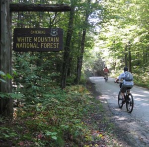 We turned east (left) on Dolly Copp Rd, a seasonal road that passes through the White Mountain National Forest and connects Rte 2 and Rte 16. We definitely appreciated the thick shade as the terrain got steeper – no rail-way grade here, but the 2 mile climb to the height of land is nicely modulated. A few cars passed us, but we mostly had the alternately rough aslphalt/ packed, dirt road to ourselves. Just over one mile from the Rail Trail on the right, is the Town Line Brook Trail – it’s an easy 0.2 mile walk to the scenic Triple Falls. It’s supposed to be most dramatic after a rain storm, but it was quite scenic even with a low flow. It’s a steep, narrow gorge with plenty of lush moss. We appreciated the break and got back on our bikes to finish our climb. You’ll know you’ve reached the height of land when you see the parking lot and trail head for the Pine Link Trail which goes up Mt. Madison. Coasting down was lovely, but once we realized there were potholes of various sizes dotting the road, camouflaged by the shadows from the trees, we slowed our descent.
About one mile down, we passed, on our left, the gated entrance to a snowmobile route – Bear Springs Trail. It is a more rugged path with several ups and downs, some uneven terrain as well as a few muddy patches to navigate. Being novice mountain bikers, we stayed on Dolly Copp Rd out to Rte 16, roughly another mile. Here, we turned north, left, on Rte 16 and cruised easily on a wide, smooth shoulder downhill all the way back to Gorham. We missed the peace and quite of the woods, but got to admire a handsome, BIG moose, eating brush along the roadside. Once in town, we stopped at the White Mountain Cafe (212 Main Street, Gorham, NH 03581, 603.466.2511) – one of our favorite places for a caffeinated beverage, lunch and cookie. To finish our ride, we turned left onto Bellvue Place at the sign for the Gorham airport, and followed this quiet, dead-end street to a big locked gate, that conveniently has a well-worn path for bikes and walkers to get around. This packed dirt road took us back to the Rail Trail parking lot on Rte 2 where we started. Including the stops at the mineral springs bottling plant, short hike up to admire the triple falls and wild-life photography, we made the approximately 15 mile trip in less than 3 hours.