Spring has officially sprung in the North Country. Now it’s time to get out there and explore those trails! If you want to hike like a local, here are a couple hidden gems we like to keep all to ourselves.
 A short easy hike would be onto Mount Jasper. It is located right behind the Berlin High School and is only ¾ mile long. The mountain itself is only 1,584’ so this hike is good for beginners and for the kids! As you make your way towards the summit there are informational signs telling you about the natural cultural history of the mountain. Once you arrive at the summit you are greeted with front row views of the wind turbines across the way at Jericho Mountain. This hike typically takes no longer than 1 hour.
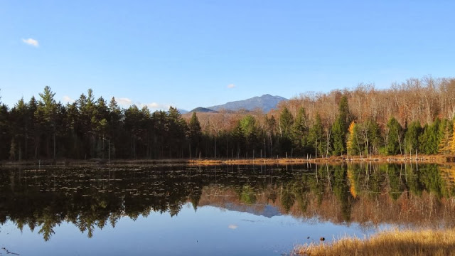
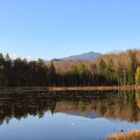 An intermediate hike would be to Mascot Pond, the hike starts in Gorham at the old railroad trestle that crosses the Androscoggin River. From there you follow the AMC Trail signs. It’s a one-mile hike to the trailhead. On the way to the trail head you will cross a bridge which is located on the ATV trail, after you cross the bridge on the ATV trail you take a direct right which leads you straight to onto the Mahoosuc Trail. Continue as if you were heading to Mount Hayes, soon after you start up the trail you will cross under power lines. After about ½ mile, you will reach a side trail to Mascot Pond on the right. Take the side trail, it’s flat from this junction all the way to the pond, only about two minutes. Once you reach the sandy shores of Mascot Pond you can see all the way to Mt. Washington on a clear day. If you turn around and look behind you, there is a large rock slide, which back in 1881 used to be home to the Mascot Mine. If you are up for more of an adventure, climb to the top of the rock slide an you will find the old mine entrances. They have since been closed off, but it is a sight to see. The mines now are protected as they are now home to over 1500 bats which range from 5 different species that hibernate in the caves. This hike in total round trip will take you roughly around 2 hours.
 If you are looking for a longer more experienced hike, then tie up your hiking boots and head over to Mount Success. This mountain is the last NH summit encountered by the north-bound hikers of the Appalachian Trail, and among locals this mountain is also known as the site of the airplane crash from 1954. Most of the AT hikers start this trail from Gentian Pond, located in Shelburne, taking off from that location however would be a 2-day hike. The less well-known approach, would be to start off from Success Pond Road in Berlin. The Success Pond Trail will start you at 5.4 Miles in and ascends for 2 miles where you will reach the rocky ledge with views of Berlin and the Presidentials. When you walk a little further you will see where the AT intersects and continue with that trail for another 0.6 miles to the summit of Mount Success, the summit is 3,565’. If you continue east on the AT for about 10 more minutes after reaching the summit you will then be walking parallel of the wreckage of the November 30th, Northeast Airlines Flight 792 crash site. Many pieces of the wreck have been taken over the year but even after 64 years the main fuselage, wings and tail are still quite recognizable and visible from the trail. This hike would be an all-day hike ranging on your experience it could take up to 2 to 5 hours.
Contributed by Kimberly Roy
Androscoggin Valley Chamber of Commerce